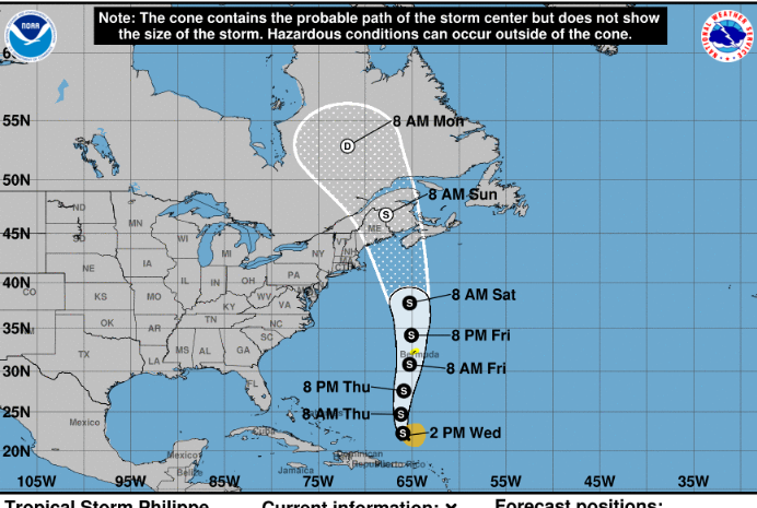
At 200 PM AST (1800 UTC), the center of Tropical Storm Philippe was located near latitude 22.0 North, longitude 65.8 West. Philippe is moving toward the north-northwest near 9 mph (15 km/h), and this motion is expected to continue today. A northward motion at a faster forward speed is forecast to begin tonight and continue into the weekend. On the forecast track, the center of Philippe will approach Bermuda Thursday night and Friday.
Maximum sustained winds are near 45 mph (75 km/h) with higher gusts. Little change in strength is forecast during the next couple of days. Some strengthening is possible late this week.
Tropical-storm-force winds extend outward up to 150 miles (240 km)to the east of the center. A sail drone located about 110 miles (175 km) southeast of Philippe’s center recently reported a sustained wind of 33 mph (54 km/h) and a gust to 42 mph (68 km/h).
The minimum central pressure based on dropsonde and buoy data is 1005 mb (29.68 inches).
RAINFALL: Philippe is forecast to produce the following additional rainfall totals through today:
The U.S. and British Virgin Islands: 1 to 3 inches, with storm totals of 6 to 12 inches.
LOCATION…22.0N 65.8W
ABOUT 255 MI…410 KM NNW OF ST. THOMAS
ABOUT 715 MI…1150 KM S OF BERMUDA
MAXIMUM SUSTAINED WINDS…45 MPH…75 KM/H
PRESENT MOVEMENT…NNW OR 340 DEGREES AT 9 MPH…15 KM/H
MINIMUM CENTRAL PRESSURE…1005 MB…29.68 INCHES
Forecaster Berg


