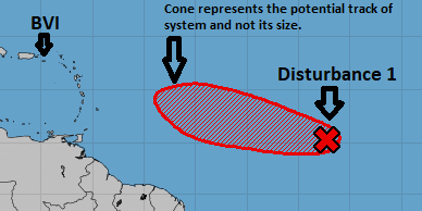
4th July 2018 – According to the National Hurricane Centre, shower activity associated with a small area of low pressure and a tropical wave located about 1000 miles west-southwest of the Cabo Verde Islands continues to become better organized. A tropical depression is likely to form during the next day or two while the System moves westward to West-Northwestward at 15 to 20 mph over the tropical Atlantic Ocean. By the weekend, however, upper-level winds are expected to become less conducive for development when the System approaches the Lesser Antilles.
The system has now been upgraded to a 70 percent chance of development increasing the chances of it being a tropical depression in about two days.
Presently the System is expected to be a tropical wave when it reaches the vicinity of the British Virgin Islands and is expected to bring showers and thunderstorms however, these conditions can change as the system progresses further westward. Residents and visitors should continue to monitor the system and expedite preparations as we continue to move further into the hurricane season.
The Department of Disaster Management will continue to monitor the system and provide updates accordingly. Please visit the DDM’s website at www.bviddm.com and subscribe for updates or like us on facebook at facebook.com/bvi.ddm
Disclaimer: The Department of Disaster Management (DDM) is not an official Meteorological Office. The Information disseminated by the Department is gathered from a number of professional sources used or contracted by the DDM to provide such information. This information is to be used as a guide by anyone who has interest in local weather conditions. By no means can the DDM or the BVI Government be held accountable by anyone who uses this information appropriately for legal evidence or in justification of any decision which may result in the loss of finances, property or life.


