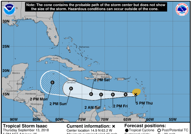
SEPTEMBER 13TH 2018, 6PM
LOCATION: 14.9 NORTH 63.2 WEST
GEOGRAPHIC REFERENCE: 220 MILES SOUTH, SOUTH EAST OF ST. CROIX
MAXIMUM SUSTAINED WINDS: 40 MPH
PRESENT MOVEMENT: AT 16 MPH
WATCHES AND WARNINGS
——————————
ALL WATCHES AND WARNINGS HAVE BEEN LIFTED.
SITUATION
Forecasters have indicated that Isaac continues to weaken and has moved further south; however outer rain bands still have the potential to create showers and a moderate chance of thunderstorms.
WINDS: 20 mph with higher gusts are possible.
RAINFALL: Less than one inch is predicted for the Territory; however outer rain bands can increase this amount.
SEAS: Seas as high as 7 feet possible. A small craft advisory is in effect. Small craft operators should stay in port. Sea bather warnings are also in effect for breaking waves and dangerous rip currents.
STORM SURGE: Some coastal flooding is possible on southern facing roads in areas of onshore winds.
The Department of Disaster Management (DDM) will continue to monitor the system and provide updates accordingly.
Persons at home and abroad are encouraged to download the DDM’s Alert app in the Apple App store or Google Play store to receive updates of any hazards affecting the Territory.
You can also visit the DDM’s webpage at www.bviddm.com and subscribe for updates or like us on Facebook at www.facebook.com/bvi.ddm.
Disclaimer: The Department of Disaster Management (DDM) is not an official Meteorological Office. The Information disseminated by the Department is gathered from a number of professional sources used or contracted by the DDM to provide such information. This information is to be used as a guide by anyone who has interest in local weather conditions. By no means can the DDM or the BVI Government be held accountable by anyone who uses this information appropriately for legal evidence or in justification of any decision which may result in the loss of finances, property or life.


