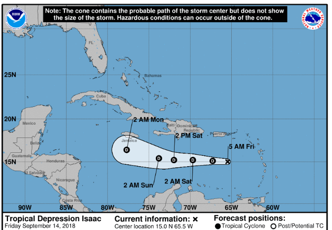
SEPTEMBER 14TH 2018, 5AM
LOCATION: 15.0 NORTH 65.5 WEST
GEOGRAPHIC REFERENCE: OVER 200 MILES SOUTH WEST OF THE BVI
MAXIMUM SUSTAINED WINDS: 35 MPH
PRESENT MOVEMENT: 15 MPH
This is the final advisory being issued through the DDM on Isaac. Regular forecasts will resume.
SITUATION
Forecasters have indicated that although Isaac (now a tropical depression) has passed, the Territory will experience overcast skies and possible showers; some showers could be heavy in conjunction with thunderstorms. Unstable conditions may persist into this evening.
WINDS: 25mph with higher gusts possible.
RAINFALL: Less than one inch is predicted for the Territory; however outer rain bands can increase this amount.
SEAS: 10 feet seas are possible. Warnings are in place for hazardous sea conditions. Small craft operators should stay in port and sea bather warnings are also in effect due to breaking waves and dangerous rip currents.
STORM SURGE: Some coastal flooding is possible on southern facing roads in areas of onshore winds.
The Department of Disaster Management (DDM) will continue to monitor the systems and provide updates accordingly.
Persons at home and abroad are encouraged to download the DDM’s Alert app in the Apple App store or Google Play store to receive updates of any hazards affecting the Territory.
You can also visit the DDM’s webpage at www.bviddm.com and subscribe for updates or like us on Facebook at www.facebook.com/bvi.ddm.
Disclaimer: The Department of Disaster Management (DDM) is not an official Meteorological Office. The Information disseminated by the Department is gathered from a number of professional sources used or contracted by the DDM to provide such information. This information is to be used as a guide by anyone who has interest in local weather conditions. By no means can the DDM or the BVI Government be held accountable by anyone who uses this information appropriately for legal evidence or in justification of any decision which may result in the loss of finances, property or life


