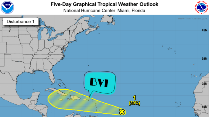
𝐈𝐧𝐯𝐞𝐬𝐭 𝟗𝟓𝐋 𝐃𝐨𝐰𝐧𝐠𝐫𝐚𝐝𝐞𝐝 𝐟𝐫𝐨𝐦 𝟒𝟎% 𝐭𝐨 𝟑𝟎%
Tropical Weather Outlook NWS National Hurricane Center Miami FL 200 PM EDT Tue Jun 29 2021 For the North Atlantic…Caribbean Sea and the Gulf of Mexico:
1. Disorganized showers and thunderstorms continue in association with a tropical wave located over the tropical Atlantic about 650 miles east of the Lesser Antilles. Some slow development of this disturbance is possible later this week while the system moves westward to west-northwestward at 20 to 25 mph, likely reaching the Lesser Antilles by Wednesday night. Regardless of development, this system could bring locally heavy rainfall to portions of the Lesser Antilles during the next few days.
* Formation chance through 48 hours…low…20 percent. * Formation chance through 5 days…low…30 percent.
Let’s continue to monitor systems in the Atlantic that could affect the BVI. Remember, it’s better to be prepared for nothing than to be caught off guard by something. Every household should have an emergency plan and emergency supply kit to #BeReady in case of an emergency. Persons at home and abroad are encouraged to download the DDM Alert App from the App Store or Google Play. Visit bviddm.com and subscribe for email updates, or follow us here on Facebook.
𝘿𝙞𝙨𝙘𝙡𝙖𝙞𝙢𝙚𝙧: 𝙏𝙝𝙚 𝘿𝙚𝙥𝙖𝙧𝙩𝙢𝙚𝙣𝙩 𝙤𝙛 𝘿𝙞𝙨𝙖𝙨𝙩𝙚𝙧 𝙈𝙖𝙣𝙖𝙜𝙚𝙢𝙚𝙣𝙩 (𝘿𝘿𝙈) 𝙞𝙨 𝙣𝙤𝙩 𝙖𝙣 𝙤𝙛𝙛𝙞𝙘𝙞𝙖𝙡 𝙈𝙚𝙩𝙚𝙤𝙧𝙤𝙡𝙤𝙜𝙞𝙘𝙖𝙡 𝙊𝙛𝙛𝙞𝙘𝙚. 𝙏𝙝𝙚 𝙄𝙣𝙛𝙤𝙧𝙢𝙖𝙩𝙞𝙤𝙣 𝙙𝙞𝙨𝙨𝙚𝙢𝙞𝙣𝙖𝙩𝙚𝙙 𝙗𝙮 𝙩𝙝𝙚 𝘿𝙚𝙥𝙖𝙧𝙩𝙢𝙚𝙣𝙩 𝙞𝙨 𝙜𝙖𝙩𝙝𝙚𝙧𝙚𝙙 𝙛𝙧𝙤𝙢 𝙖 𝙣𝙪𝙢𝙗𝙚𝙧 𝙤𝙛 𝙥𝙧𝙤𝙛𝙚𝙨𝙨𝙞𝙤𝙣𝙖𝙡 𝙨𝙤𝙪𝙧𝙘𝙚𝙨 𝙪𝙨𝙚𝙙 𝙤𝙧 𝙘𝙤𝙣𝙩𝙧𝙖𝙘𝙩𝙚𝙙 𝙗𝙮 𝙩𝙝𝙚 𝘿𝘿𝙈 𝙩𝙤 𝙞𝙢𝙥𝙧𝙤𝙫𝙞𝙙𝙚 𝙨𝙪𝙘𝙝 𝙞𝙣𝙛𝙤𝙧𝙢𝙖𝙩𝙞𝙤𝙣. 𝙏𝙝𝙞𝙨 𝙞𝙣𝙛𝙤𝙧𝙢𝙖𝙩𝙞𝙤𝙣 𝙞𝙨 𝙩𝙤 𝙗𝙚 𝙪𝙨𝙚𝙙 𝙖𝙨 𝙖 𝙜𝙪𝙞𝙙𝙚 𝙗𝙮 𝙖𝙣𝙮𝙤𝙣𝙚 𝙬𝙝𝙤 𝙝𝙖𝙨 𝙞𝙣𝙩𝙚𝙧𝙚𝙨𝙩 𝙞𝙣 𝙡𝙤𝙘𝙖𝙡 𝙬𝙚𝙖𝙩𝙝𝙚𝙧 𝙘𝙤𝙣𝙙𝙞𝙩𝙞𝙤𝙣𝙨. 𝘽𝙮 𝙣𝙤 𝙢𝙚𝙖𝙣𝙨 𝙘𝙖𝙣 𝘿𝘿𝙈 𝙤𝙧 𝙩𝙝𝙚 𝘽𝙑𝙄 𝙂𝙤𝙫𝙚𝙧𝙣𝙢𝙚𝙣𝙩 𝙗𝙚 𝙝𝙚𝙡𝙙 𝙖𝙘𝙘𝙤𝙪𝙣𝙩𝙖𝙗𝙡𝙚 𝙗𝙮 𝙖𝙣𝙮𝙤𝙣𝙚 𝙬𝙝𝙤 𝙪𝙨𝙚𝙨 𝙩𝙝𝙞𝙨 𝙞𝙣𝙛𝙤𝙧𝙢𝙖𝙩𝙞𝙤𝙣 𝙖𝙥𝙥𝙧𝙤𝙥𝙧𝙞𝙖𝙩𝙚𝙡𝙮 𝙛𝙤𝙧 𝙡𝙚𝙜𝙖𝙡 𝙚𝙫𝙞𝙙𝙚𝙣𝙘𝙚 𝙤𝙧 𝙞𝙣 𝙟𝙪𝙨𝙩𝙞𝙛𝙞𝙘𝙖𝙩𝙞𝙤𝙣 𝙤𝙛 𝙖𝙣𝙮 𝙙𝙚𝙘𝙞𝙨𝙞𝙤𝙣 𝙬𝙝𝙞𝙘𝙝 𝙢𝙖𝙮 𝙧𝙚𝙨𝙪𝙡𝙩 𝙞𝙣 𝙩𝙝𝙚 𝙡𝙤𝙨𝙨 𝙤𝙛 𝙛𝙞𝙣𝙖𝙣𝙘𝙚𝙨, 𝙥𝙧𝙤𝙥𝙚𝙧𝙩𝙮 𝙤𝙧 𝙡𝙞𝙛𝙚..


