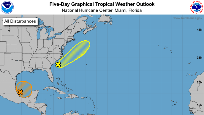
Disturbance #1. According to the National Hurricane Centre as of 2pm.A large area of showers and thunderstorms over the Bay of Campeche is associated with a broad low pressure area, and the overall system has become somewhat better organized since yesterday. Slow development is possible during the next few days while the system meanders near the coast of Mexico, and a tropical depression could form late in the week while the system begins to move slowly northward. Regardless of development, heavy rainfall is possible over portions of Central America and southern Mexico during the next several days.
Disturbance #2. According to the National Hurricane Centre as of 2pm.A non-tropical area of low pressure has formed about 150 miles south of Wilmington, North Carolina and is producing disorganized showers and thunderstorms. This system is forecast to move northeastward for the next few days near the warm Gulf Stream, which could allow for some tropical development to occur while it moves away from the United States. The low should be over cold waters south of Nova Scotia by midweek, ending its development chances.
These disturbances pose no threat to the British Virgin Islands.
Disclaimer: The Department of Disaster Management (DDM) is not an official Meteorological Office. The Information disseminated by the Department is gathered from a number of professional sources used or contracted by the DDM to provide such information. This information is to be used as a guide by anyone who has interest in local weather conditions. By no means can DDM or the BVI Government be held accountable by anyone who uses this information appropriately for legal evidence or in justification of any decision which may result in the loss of finances, property or life.


