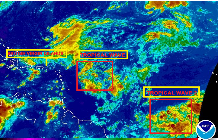
A tropical wave is located 720 miles to the east of Martinique along 50W. It is moving to the west-northwest at 13 mph. Due to the strong westerly wind shear over the disturbance, most of the shower and thunderstorm activity is located east of the tropical wave axis. There is a 30 percent chance of tropical development over the next seven days. The wave has its best chance for development for the middle to latter part of this week. If the wave were to develop, it could become a tropical depression or weak tropical storm as some model guidance suggests. Regardless of development, the system will produce increased shower and thunderstorm activity across Hispaniola, Cuba, and the Bahamas on Thursday into Friday. The wave is expected to pass north of the Leeward Islands however we will continue to monitor wave as it progresses and advise of any changes.
A second tropical wave is located over 500 miles to the south-southwest of the Cape Verde Islands along 28W. It is moving to the west at 22 mph. Environmental conditions will not be favorable for tropical development over the next several days. There is a 10 percent chance of development over the next seven days. This disturbance will move across the Lesser Antilles Saturday and increase shower and thunderstorm activity.
Please continue to monitor local media stations, DDM’s website (bviddm.com) and Facebook at BVIDDM for regular updates.
Disclaimer: The Department of Disaster Management (DDM) is not an official Meteorological Office. The Information disseminated by the Department is gathered from a number of professional sources used or contracted by the DDM to provide such information. This information is to be used as a guide by anyone who has interest in local weather conditions. By no means can the DDM or the BVI Government be held accountable by anyone who uses this information appropriately for legal evidence or in justification of any decision which may result in the loss of finances, property or life.


